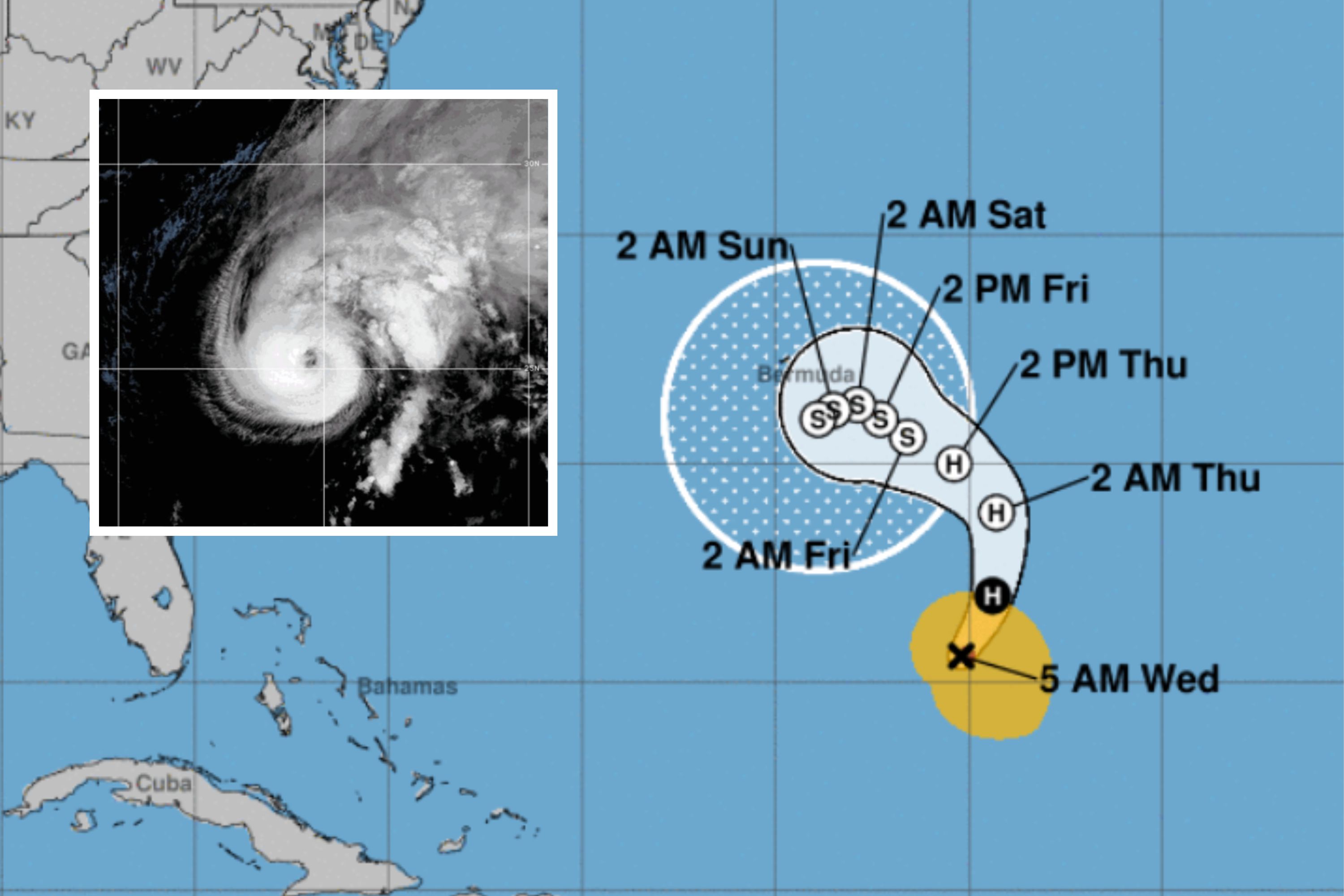
Hurricane Tammy may be about to veer towards the U.S., bringing heavy rain and strong winds.
Spaghetti models of the storm show that some of its potential paths include it making landfall in Florida, or alternatively in North Carolina, but that other possible paths could send it careening in the opposite direction into the Atlantic.
“This has to be among the craziest spaghetti models ever for a hurricane,” Eliot Jacobson, a retired professor of mathematics and computer science, posted to X, formerly Twitter, over a model by meteorologist Levi Cowan.
According to the National Hurricane Center, Tammy, which is currently a Category 1 hurricane, has “maximum sustained winds [that] have increased to near 85 mph with higher gusts.”
Spaghetti plots are a tangled cluster of all the potential paths that a storm could take, depending on the conditions it faces.
“Each spaghetti model represents the storm’s, in this case Tammy’s, path in a different weather model forecast,” Quinton Lawton told Newsweek. Lawton is a PhD researcher in atmospheric sciences at the Rosenstiel School of Marine, Atmospheric, and Earth Science, University of Miami.
“What weather models do is take in a lot of current weather data from around the world—from satellites, weather instruments, aircraft observations—and make a ‘best guess’ at what the atmosphere looks like at a given time.
“Then it solves a set of physics equations to predict what will happen to the weather in the future, based on those current conditions. Each weather model is slightly different in how it makes this initial best guess and in the details of how it solves these equations, so spaghetti models help us compare what different models are predicting into a single image,” he said.
Some spaghetti plots are made using ensemble forecast systems, which involve a set of multiple weather forecasts being produced for each model.
“What typically happens is that the initial ‘best guess’ of what the atmosphere looks like is randomly, and very slightly, adjusted prior to running each ‘member’ of the set of forecasts. What this does is give us an idea of the uncertainty of the forecast,” Lawton explained.
“If those model plots stay close together even after this random adjustment, it gives us more certainty in the overall forecast. But when they are pretty spread apart, like now with Tammy, it indicates that there is more uncertainty in the forecast.”
A storm or hurricane such as Tammy can change direction due to a number of factors, which may lead it along one or another of the strands of a spaghetti plot.
Chris Slocum told Newsweek that the placement of middle latitude troughs is key to the direction a hurricane or tropical storm might take.
Slocum is a physical scientist at the National Oceanic and Atmospheric Administration Center for Satellite Applications and Research.
“Troughs basically act like a wall that tropical cyclones cannot cross and cause the tropical cyclone to recurve and start moving northwest. From the storm perspective, the storm’s thunderstorm organization, strength of the winds, and size of the storm impact where a storm will go. The strands highlight the impact of all these factors on where a storm might go,” he said.
Tammy’s unpredictability is in part due to how late in the hurricane season it is.
“Late in the north Atlantic hurricane season, tropical cyclones begin to interact with the lower-latitude extending troughs, which are associated with variable fall weather over the continental United States,” Slocum said.
“During the peak of the hurricane season, storms may dissipate over cold ocean water before interacting with a higher-latitude trough. In general, trough interaction makes tropical cyclone track more uncertain. Ensemble simulations capture differences in the timing and strength of the trough to provide multiple possibilities [of] how the storm will interact with the trough,” Slocum said.
“This makes Tammy’s track typical for a late season north Atlantic tropical cyclone interacting with a trough. The large variability gives forecasters at the National Hurricane Center an idea of uncertainty in the storm’s track, which they can use to monitor the interaction between Tammy and the trough via satellite imagery and to then convey uncertainty to the public,” he said.
The National Hurricane Center forecasts that Tammy is due to move west, hitting Bermuda by Thursday, but will begin to weaken in the coming days.
“Some additional strengthening is possible through early Wednesday, followed by weakening through late this week. Tammy is forecast to become a powerful post-tropical cyclone by Thursday,” a public advisory reads.
Do you have a tip on a science story that Newsweek should be covering? Do you have a question about Hurricane Tammy? Let us know via science@newsweek.com.

